ALLPCB


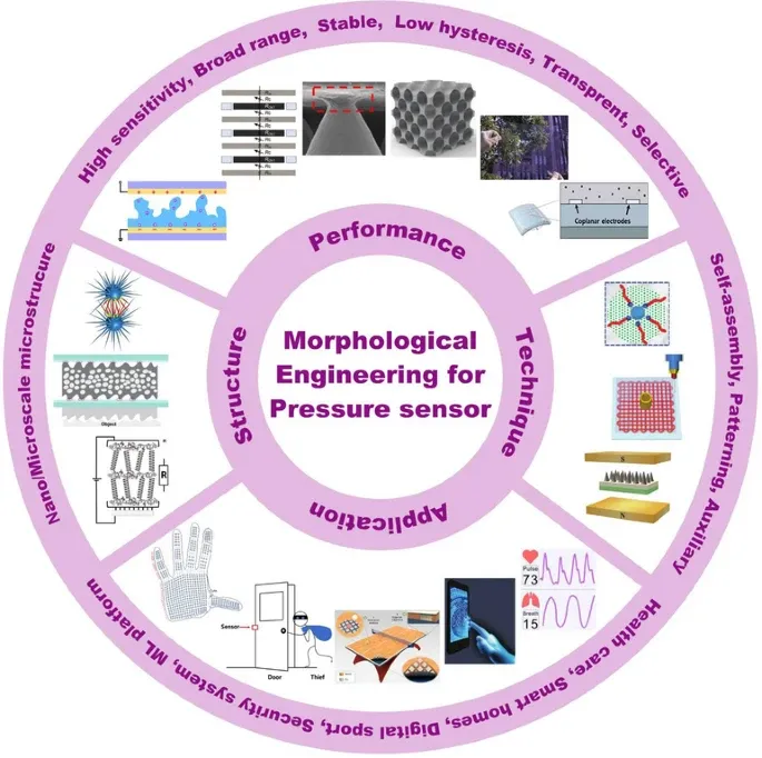
Overview
Accurate location data is critical for vehicle navigation, ride sharing and other mobility services. Delivering precise, current position information is challenging because vehicles and devices operate in varied and often harsh environments. Relying on a single sensor technology cannot guarantee consistent results across all scenarios. Sensor fusion integrates data from multiple sensors to compensate for the limitations of individual technologies and improve overall positioning accuracy.
What is sensor fusion and why it matters
Sensor fusion for positioning combines data from multiple sensors to produce a more accurate and complete estimate of a vehicle or device position and state. It is used in GNSS navigation, automated driving, commercial robots, e-bikes, e-scooters and other mobile platforms. By fusing complementary sensor inputs, systems can maintain situational awareness even in environments that challenge traditional positioning methods.
Impact on mobility applications
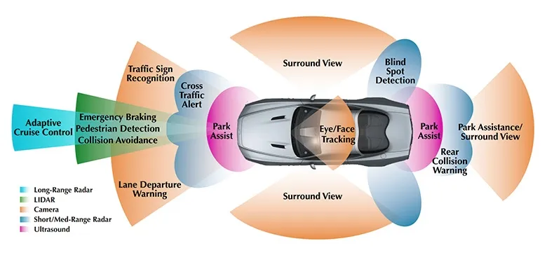
For end users, sensor fusion improves vehicle and smartphone navigation. It is also applied in autonomous and semi-autonomous vehicles, automated mobile robots (for example, delivery robots) and micromobility platforms, with new use cases emerging regularly.
Absolute vs. relative positioning and required sensors
Absolute positioning specifies position relative to a global reference (for example latitude, longitude and altitude). Relative positioning estimates current position based on a previously known position, using motion and orientation data. Both approaches have uses and limitations, and they are often combined for best results.
Typical absolute-positioning sensors
- GNSS (global navigation satellite systems) or GPS
- Wi?Fi positioning
- Cellular base-station triangulation
- Geomagnetic positioning
- Map-based localization using camera, lidar or radar perception
Typical relative-positioning sensors
- Inertial navigation: gyroscopes and accelerometers
- Barometer for relative altitude
- Visual sensors for lane following and odometry
Positioning challenges
Using only an absolute or only a relative solution can introduce ambiguity and uncertainty. For example, GNSS reception can be lost in tunnels or urban canyons, causing a navigator to miss an upcoming exit. In such cases, inertial and other relative sensors can help bridge GNSS outages, while map- or vision-based methods can assist in complex urban environments.
Sensor-fusion solution examples
Some suppliers offer sensor-fusion software packages targeted at different mobility segments. For example, one vendor provides three product lines described here in neutral terms:
- RIDE: A solution focused on micromobility fleet management that estimates vehicle heading and position for fleet tracking, parking monitoring and behavior analysis.
- TRACK: Inertial dead-reckoning software designed to maintain vehicle position where GNSS signals are limited, such as parking structures, dense urban centers and tunnels. TRACK interfaces with a range of hardware, processors and sensors.
- AUTO: A package intended for automated and semi-automated vehicles and robotic applications. AUTO integrates automotive-grade IMUs, vehicle-speed sensors, high-precision GNSS and perception sensors with synchronized timestamps to provide improved position accuracy and integrity for wheeled vehicles.
The supplier's approach emphasizes software-centered sensor fusion and offers application-specific products rather than a one-size-fits-all inertial solution. The software can also provide auxiliary features such as driving-dynamics detection, theft detection and trailer-detection functions. Integrations can be adapted to work with customer-supplied sensors or GNSS hardware, allowing software adjustments without requiring custom hardware development.
Future trends
As software-defined vehicles and connected mobility platforms become more prevalent, software-driven positioning functionality will take on an increasingly central role. Connectivity technologies such as 5G are expected to further improve positioning and navigation capabilities, facilitating updates, data transfer and integration into future smart-vehicle architectures.